
- Overview
- Spotlight
- Photos
Gateway Natural Area is the City of Fort Collins’ first mountain park. In 1903, the City of Fort Collins opened a water treatment facility at the confluence of the Cache la Poudre River and its North Fork tributary. Through the years, a small park was established at the site. Depression-era Civilian Conservation Corps helped build several trails and roads here and in the surrounding areas. Evidence of their work and skills can still be viewed by visitors to the area.
Gateway was closed to the public in the late 1970s because of safety concerns, and the water treatment facility was closed in the late 1980s due to limited pipeline capacity and increasing water needs. In the summer of 2002, the City of Fort Collins once again opened the area to the public as Gateway Mountain Park. It was in late 2006 that the City of Fort Collins Natural Areas Program took over management and re-named it Gateway Natural Area.
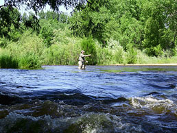
Today, Gateway provides a respite from the hustle and bustle of daily life. It’s a lovely spot to spend the day with family and friends, hiking its many trails or following the river’s path as you kayak in its waters. Fishing, picnicking, and partaking in the natural world are all great activities to enjoy here. The Ponderosa pine habitat, lower elevation spruce and fir forests, and hilly arid scrub and riparian canyons found here offer the opportunity to observe numerous bird species—Lazuli Buntings, Black-headed Grosbeaks and Western Tanagers commonly breed here, while the American Dipper and Common Merganser nest near the river. Common Poorwills call from dry hillsides on summer evenings, and Flammulated Owls and Lewis's Woodpeckers use the large cottonwoods in the riparian canyons. Northern Pygmy Owl and Northern Shrike hunt in the riparian habitat during winter, and the canyon cliffs attract nesting Golden Eagles, White-throated Swifts and Violet-green Swallows. Gateway is a place that offers you a variety of trails to enjoy along your own personal journey.
The Cache la Poudre River is probably the single most significant natural feature in this part of northern Colorado. Where the river leaves the mountains and flows across the high plains, the first Euro-American settlement in the area sprang up (Colona, later renamed Laporte). Prior to that, the open valley where the river emerges from its canyon was a favorite area of the Arapaho, who maintained large encampments there. After a flood in 1864, the military’s Camp Collins was relocated from Laporte several miles downstream at the place where Fort Collins later was born.
According to local legend, the river got its name from the French words for “hide the powder.” As the story goes, in 1836 a group of French fur trappers were caught in a snowstorm near present-day Laporte. Unable to carry their heavy supplies through the bad weather, they decided to cache, or hide, their gunpowder at a hidden location near the river, so they could return at a later time to retrieve it.
But the real treasure of the river in this arid land is its water. In 1860, the first irrigation ditch taking water from the Cache la Poudre River was built by G.R. Sanderson. The Poudre is still a vital source of irrigation water for dry land farmers today, feeding an intricate network of ditches and reservoirs. Further upstream, the river is prized—and protected—as a natural resource in its own right. In 1986, the Cache la Poudre was named a National Wild and Scenic River, the first in Colorado. This designation has helped protect the Poudre’s wild fish, animals, and birds, and to preserve it as a premier recreational area for generations to come.
Click any of the red pins on the map to see visitor information about that site.
Download a printable version of Tour 1 complete with directions, maps, and activities.
Open this tour in Google Earth by downloading the KML version of this map.
Download a PDF of the brochure for Gateway Natural Area.
Red Mountain Open Space
- Managing Agency
- Larimer County Department of Natural Resources
- Open
- March 1 to November 30
- Fees
- None. Consider purchasing a Park Permit to help support Larimer County Department of Natural Resources
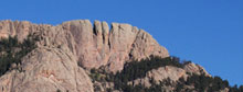
Red Mountain Open Space is rugged and remote - always carefully prepare for your experience. Carry plenty of water and extra food. Watch the weather closely - fast-moving thunderstorms and high winds are common.
Read the brochure for all the rules and regulations.
Hiking the Anticline Trail
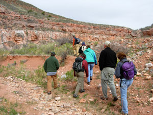
photo by Terry Burton
Gateway Natural Area
- Managing Agency
- City of Fort Collins Natural Areas Program
- Hours
- Sunrise to sunset
- Fees
- Required March 1-November 30
- $5.00 per standard vehicle
- $10.00 per commercial vehicle, bus, motor home,trailer, or van occupied with 8 or more passengers. Annual pass available.
Hiking, fishing, picnicking, and relaxing by the river makes Gateway a place for all. Each season is special - visit all year round. For your protection, no overnight parking or alcohol is allowed at Gateway. All pets must be leashed. Use grills provided or table-top gas grills only.
For information on renting a picnic shelter rental, call 970-416-2815.
Fall reflections along the Poudre
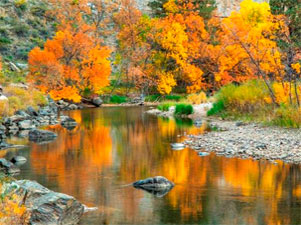
photo by Richard Ernst
Reservoir Ridge Natural Area
- Managing Agency
- City of Fort Collins Natural Areas Program
- Hours
- 5:00 am to 11:00 pm
- Trails
- About 3.5 miles of soft surface trail. Connects to the Foothills Trail.
Visitors to this foothills natural area enjoy its rugged trails, access to the 6.8 mile Foothills Trail, wildlife viewing opportunities and a feeling of remoteness-- all close to Fort Collins. You’ll see dramatic rock outcroppings, grasslands, mountain mahogany shrubs and a few ponderosa pines. Views of the city and Horsetooth Reservoir are great from the trails!
Flowers on the hillside
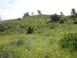
photo by City of Fort Collins Natural Areas Program
Horsetooth Mountain Open Space
- Managing Agency
- Larimer County Department of Natural Resources
- Open
- Open year-round from sunrise to sunset
- Fees
- Park permit required for all visitors, including walk-in and bike-in
Horsetooth Mountain Open Space (consisting of Culver, Soderberg, and Hughey Open Spaces) is a scenic 2,711 acre park located on the west side of Horsetooth Reservoir. This is a very popular open space, so if you should arrive and find the parking lot full you will know that the trails are at maximum capacity. Please consider one of our other open spaces for your outdoor enjoyment that day, and come back to Horsetooth Mountain Open Space another time.
Read the brochure for all the rules and regulations.
Mountain biking in Horsetooth Mountain Open Space
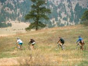
photo by Mike Strunk
Bobcat Ridge Natural Area
- Managing Agency
- City of Fort Collins Natural Areas Program
- Hours
- Open daily from dawn until dusk
- Trails
- Valley Loop (4 mile loop), Ginny Trail (5.4 miles, climbs 1,500 feet, open for hiking and mountain biking, closed to horses), D.R. Trail (3.4 miles long, climbs 1,100 feet, open to equestrians and hikers, closed to cyclists), Powerline Road (1.5 miles long, climbs steeply with loose rocks so not recommended for horses, uphill only for cyclists), Eden Valley Spur (an out and back route, 1.3 miles along the valley bottom)
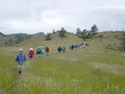
Discover Bobcat Ridge Natural Area! You’ll find a grassy valley, foothills, ponderosa pines, stunning red rock cliffs and more. Bobcat Ridge is home to elk, wild turkey, mountain lions and other wildlife. Several historic homestead sites dot the landscape.
Hiking the Valley Loop trail
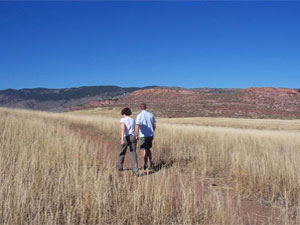
photo by City of Fort Collins Natural Areas Program
Devil's Backbone Open Space
- Managing Agency
- Larimer County Department of Natural Resources
- Open
- Open year-round from sunrise to sunset
- Fees
- None. Consider purchasing a Park Permit to help support Larimer County Department of Natural Resources
The 2198-acre Devil's Backbone Open Space provides abundant opportunities on a seven-mile trail for outdoor recreation including hiking, running, horseback riding, mountain biking, wildlife viewing, observing nature, as well as enjoying close-up inspection of the rock outcrop and long vistas of the area, while on the trail.
This is a very popular open space, so if you should arrive and find the parking lot full you will know that the trails are at maximum capacity. Please consider one of our other open spaces for your outdoor enjoyment that day, and come back to the Devil's Backbone another time.
Read the brochure for all the rules and regulations.
Devil's Backbone rock formation
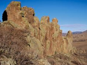
photo by Larimer County Department of Natural Resources